Extensive stakeholder engagement throughout the process ensured a functional design for both bridge and river users. This sustainable and aesthetic proposal will now be developed through detailed design phase.
The challenge
Amey was commissioned by Nottingham City Council to conduct a feasibility study for a new foot and cycle bridge in the City’s emerging Waterside area. The new crossing would link communities at either side of the River Trent, improving business links and community cohesion while also promoting sustainable transport options.
The Council identified three potential locations for the bridge and the feasibility of each option was tested. The scope for this included:
Establishing constraints, including navigational clearance, maximum ramp gradients and lengths and environmental factors
Advising on the optimal bridge location and bridge form, considering access, constructability, maintenance, material type and durability
Delivery of an options report, drawings and visualisations for stakeholder engagement and planning application
Our approach
Amey took a four-step approach to assessing feasibility. This included consideration of each proposed location and consideration of constraints followed by feasibility design development.
Location
Three potential locations were identified by the client and assessed against a range of criteria including accessibility, connections to existing and proposed infrastructure including leisure and recreation spaces, its impact on local infrastructure, functionality and access for construction and maintenance.
This assessment sought to fully understand each potential location and drew on intelligence from the Council and stakeholders, site visits and engineering resource along with site surveys encompassing topography, light detection ranging (LiDAR) and water levels. This led to ruling out one location - Trent Lane - at this early stage due to existing infrastructure on the river’s north bank that would necessitate the use of bridge piers.
Constraints
The scale of the project and its potential impact on numerous stakeholders meant a significant number of constraints had to be considered. These included navigational requirements - such as providing a minimum passable headroom and width for river users - and integrating the new crossing into the wider Waterside site as well as other existing and proposed developments.
Environmental constraints including impact on the existing flood plain and river habitats were key. A flood model was used to fully understand potential ecological effects. Other critical considerations included the impact on landowners, site access for construction and maintenance and site condition including ground make-up and existing infrastructure along with impact on stakeholders.
A wide group of affected stakeholders need to be considered. These ranged from statutory consultees such as the Environment Agency (EA) and the Canal and River Trust (CRT), to local community groups. Feasibility considerations also encompassed existing services and statutory undertaker apparatus.
Design requirements
A number of key design requirements for the bridge and ramps were identified for the feasibility design. These included cross sections of the walkway - both bridge and ramps - including minimum usable width along with maximum gradients and lengths for the walkway and provision of flat landings along with minimum headroom under the bridge at above maximum water levels.
Other critical design requirements included provision of parapets and minimum height, lighting, compliant surfacing and drainage as well as sustainability, maintenance and durability. In addition, the design needed to meet CRT and EA requirements stipulating that there must be no supports in the river.
Feasibility Design Development
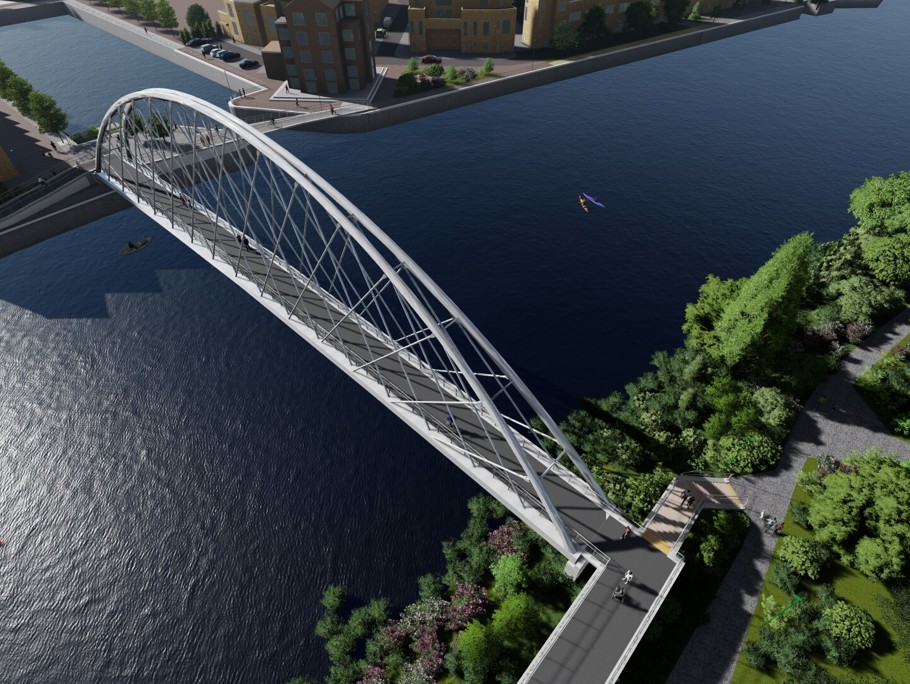
Throughout the feasibility design process, the form of bridge construction, arrangement, constructability, material choices, maintenance and operation, estimated carbon footprint and estimated cost were considered. The process included initial design of a cable stay structure at Poulton Drive - largely due to the space available for back stay cables - and a network arch structure at Trent Basin requiring smaller abutments and fitting for the limited footprint available at this location.
Both static and initial dynamic models were developed for each preferred option. Dynamic modelling identified key natural frequencies of each structure that could be susceptible to vibrations under pedestrian loading and the design was optimised to reduce these mode shapes.
This information was used to generate design drawings and visualizations and as a basis for carbon and cost accounting. These initial models will now be developed during detailed design by applying pedestrian and wind dynamic loads in accordance with Eurocode 1 and designing the structure to resist these effects.
Benefits
The feasibility process led to the recommendation of network arch bridge at Trent Basin. This offers excellent connectivity for Waterside residents and better access to sport and leisure facilities. It also offers better site access for construction as well as facilitating a temporary site compound.
The network arch construction allows for offline construction, reducing risks associated with working over water and inconvenience for river users as well as minimising the construction footprint on land. The bridge form is unique and aesthetic, making it a landmark for the local area.
The comprehensive feasibility study included 2D drawings, 3D modelling and carbon accounting estimates and informed a functional design compliant with Design Manual for Roads and Bridges, Eurocodes, British Standards and Department for Transport codes.
Ongoing client and stakeholder engagement combined with early contractor involvement allowed and comprehensive environmental surveys and flood modelling and facilitated early submission of the planning application.